Back in the 50's, workmen were putting in a drain down the hill from the High Road. Looking at the video, it would be from the top-left along the end wall leading down to Boglemart St. They discovered two Iron-age cists. I'm sure there will be reports about it somewhere.
The workers discovered the first one and reported it so that the archaeologists could investigate. That held them up for weeks. When they got back to work, apparently the workmen discovered a second one within hours and put the bulldozer through it so as not to lose any more time.
JD.
Three Towns drone images
Forum rules
Here you can show the photographs you've taken. Use a storage agent such as https://www.imgur.com - our forum attachment system has limited storage and therefore reserved for photos in our Threetowners' Photo Album.
Here you can show the photographs you've taken. Use a storage agent such as https://www.imgur.com - our forum attachment system has limited storage and therefore reserved for photos in our Threetowners' Photo Album.
-
John Donnelly

- Mega Heid Poster

- Posts: 2955
- Joined: Mon Mar 05, 2007 7:31 pm
- Location: The Netherlands
-
creamolafoam

- leading Poster

- Posts: 556
- Joined: Thu Oct 14, 2010 7:28 pm
Re: Three Towns drone images
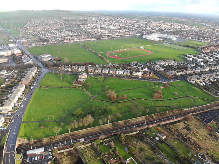
New race track getting built on part of old ici grounds
Re: Three Towns drone images
Garnock East, a former storage area for the old factory, just across the Garnock from Stevenston. Part of Garnock East is within the Stevenston parish boundary; most of it, however, is in Irvine.
Re: Three Towns drone images
What is covering the ground in the video, it seems to be kind of like snow, but it hasn't been snowing here yet.
sand maybe? any ideas?
sand maybe? any ideas?
Idiot - seeks village.

Re: Three Towns drone images
I think it was in the summer and the grass has had a lot of sun.
Those wimin were in the nip.
Re: Three Towns drone images
In the first few seconds, it’s a field of grass that looks like snow. In the rest of the video, it’s acres and acres of bulrushes – Garnock East is for the most part a large wetland. As Bonzo says, the dry summer might have made the vegetation even browner than it usually would be.
Re: Three Towns drone images
After getting a shot of the Plantation from Ardrossan South Beach, I thought I’d take some drone footage over the beach itself.
-
Hughie

- Administrator

- Posts: 11162
- Joined: Thu Dec 09, 2004 12:42 am
- Location: Australia Formerly Ardrossan
- Contact:
Re: Three Towns drone images
That is a great video, Iain. at the 3:38 mark there is a car at the round about seems to have lost its way - or was he blocking the car behind him? 


Re: Three Towns drone images
Well spotted, Hughie! How strange. And how frustrating that the drone panned away before the situation was resolved. I think you're right: the most parsimonious explanation is probably that the car took a wrong turn.
-
down south

- Mega Heid Poster
- Posts: 3545
- Joined: Mon Feb 16, 2009 4:18 pm
- Location: Cheshire,formerly Saltcoats
Re: Three Towns drone images
What are those strange key shapes cut in the grass at the end of the video, Iain ? And what is that blue shape that looks like a pond ( but I'm sure isn't ) ?
Susan
Susan
-
madge

- Frequent Poster

- Posts: 207
- Joined: Thu Nov 07, 2013 10:53 pm
- Location: Stevenston now Saltcoats
Re: Three Towns drone images
The key shapes are for the crazy golf and I think the blue is the swing park.
Madge
Madge
Trust in God but row away from the rocks
Re: Three Towns drone images
Susan, George Ardrossan posted a photo of the swing park a few years ago in another thread (http://www.threetowners.net/forum/viewt ... 731#p89649). I 'quote' the photo below:
Iain

Iain